
 Welcome to the Flight Simulation Project. Here you
can create a flight plan and fly an aircraft between two airports anywhere in the world, just as
real pilots do every day. You will use some of the same maps and tools
real pilots use to create a flight plan. When you are done and your flight
plan has been check out by your flight instructor, you may try your flight out
using our flight simulator. Use the links and tools below to begin.
Welcome to the Flight Simulation Project. Here you
can create a flight plan and fly an aircraft between two airports anywhere in the world, just as
real pilots do every day. You will use some of the same maps and tools
real pilots use to create a flight plan. When you are done and your flight
plan has been check out by your flight instructor, you may try your flight out
using our flight simulator. Use the links and tools below to begin.
Decide on a route. You and your team must be able to complete the flight within one class period, so the airports should be less than 50 miles apart. To begin,
|
Decide on a location for your flight | |
|
Click here to search for and print out an aviation map for your flight. Use their search command to locate other cities. NOTE: 4th grade must fly within New York State for the first 4 flights. | |
|
Use the Distance Calculator help calculate the miles per inch on your map and measure the distance of your flight. |
Decide on an aircraft you would
like to use. For your first few flights, you may use either as follows: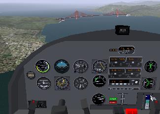
|
Flights 1 and 2
|
Flights 3 and 4
|
Fill out and print a Flight Plan for your flight.
Print out a pre-flight check-list
Bring the entire folder to your instructor for approval
Try out your flight using the free open-source flight simulator called Flightgear.
 |
 |
Click here to find our more about the free open-source flight simulator Flightgear.